Soil Practicum Scorecard | Soil Practicum Guidelines
The 2019 Soils Practicum has changed significantly from previous years. This practicum includes areas of common ground among the Idaho Soils CDE, the National FFA Environment and Natural Resources CDE, and practices used in the field by natural resource professionals.
** Guidelines for recommended treatments/practices differ from the Idaho Soils CDE in several places. Read the guidelines below and attached.
Soil Practicum – 100 points
- Students will be furnished with a scorecard, a scenario description, and a pre-dug soil pit (70 cm or to an impenetrable layer). The participants will assess or determine location in landscape, % bare ground, slope, depth of top soil horizon, depth of soil, texture or surface soil, percent of course rock fragments and permeability.
- Based on soil characteristics and knowledge or practices, the student will then identify the most appropriate use for the given area and the erosion control or land management practice that best fits the designated use for the land.
PART 1 – Soil Characterization
80 points total; 10 points each for the eight characteristics being examined
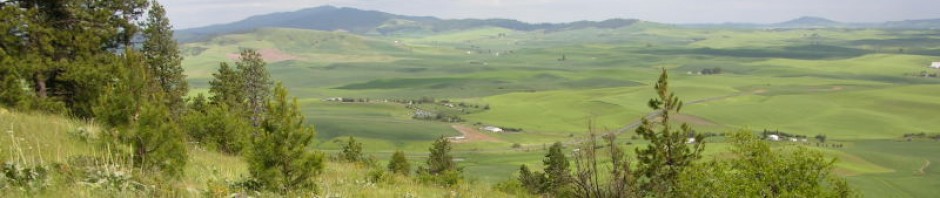
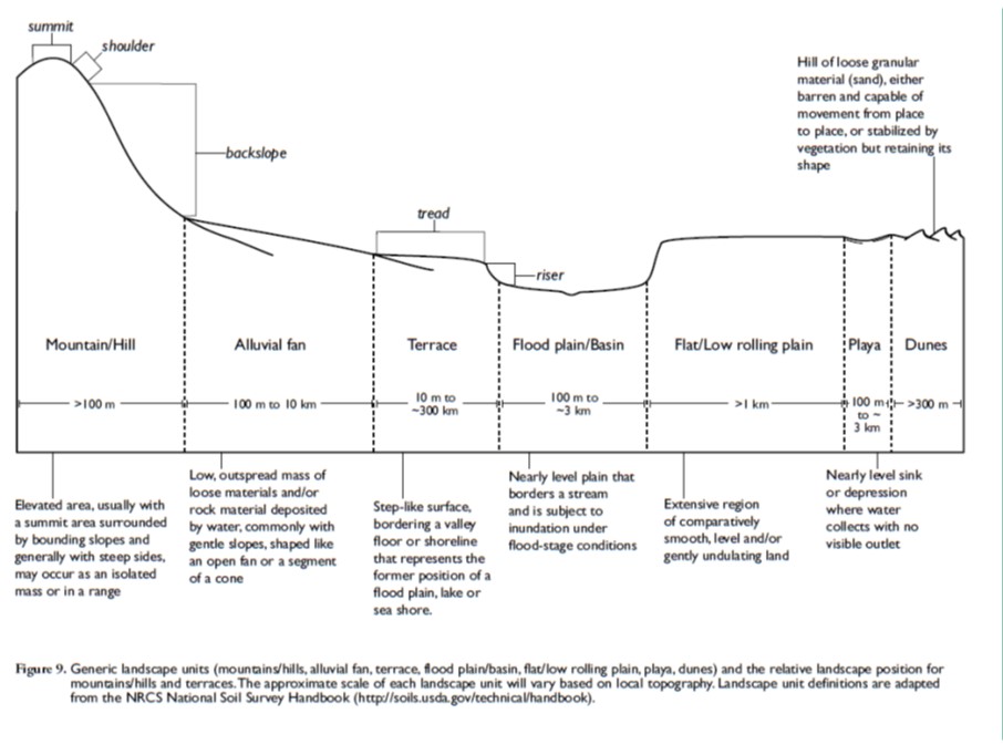
1. Location in Landscape. Students will look at the landscape around the site and determine the landscape setting as: Mountain/Hill, Alluvial fan, Terrace, Flood Plain/Basin, Flat/Low Rolling Plain, Playa, or Dune. The Landscape Context concept is used and describe in the Assessment Inventory and Monitoring Protocol (Herrick et al. 2020)
2. % Bare Ground of soil surface. A 50 cm by 50 cm plot will place on the site and participants will be asked to estimate the percent of the plot that is composed of rock and soils and not covered by vegetation or dead plant material (i.e., litter). Bare ground will be classed as: Little (0-25%), Significant (26-50%), Abundant (27-75%), or Dominant (76-100%).
3. Slope. Participants will be required to estimate slope between two flags or stakes that are spaced 100 feet apart. Clinometers will be allowed for slope determination; students may bring their own, or use one provided. Slope will be classified as: Nearly Level (0-1%), Gently Sloping (1-3%), Moderate Sloping (3-5%), Strongly Sloping (5-8%), Steep (8-15%), or Very Steep (> 15%).
A soil pit/hole will be dug to at least 28 inches (70 cm) or till a restricting layer is encountered. Meter sticks will be placed near the soil pit and participants will estimate the depth of topsoil and soil to a restricting layer.
4. Depth of Topsoil (O+A Horizon). In the soil pit/hole students will measure the depth of topsoil and categorize it as: Very Shallow (<3 inches), Shallow (3 to 6 inches), Moderately Deep (6 to 9 inches), or Deep (> 9 inches).
5. Depth of Soil to restricting layer. In the soil pit/hole students will measure the depth of topsoil and categorize it as: Very Shallow (<10 inches), Shallow (10 to 20 inches), or Deep (>20 inches).
6. Texture of Topsoil. A bucket of topsoil from the pit/hole will be labeled as “Topsoil” for participants to determine soil texture by the “Texture by Feel” method as outlined in the Soil and the Environment Training Guide (Bulletin 0795 University of Idaho, Revised 2012). Soil will be determined and classified as: Sand, Loamy Sand, Sandy Loam, Sandy Clay Loam, Sandy Clay, Loam, Silt Loam, Clay Loam, Silty Clay Loam or Clay/Silty Clay.
7. Percent Course Rock Fragment. A bucket of soil from the soil pit/hole will be spread out on a plastic sheet and labeled “Course Rock Fragment.” Participants will estimate % volume of gravel, cobbles and stones in the soil sample. Course rock fragments include any rocky material larger than 5 mm (or 0.2 inches) in diameter. The proportion of course rock fragments will be categorized as: None to Slight (<15%), Moderate (16-35%), Considerable (35-60%), or Extreme (>61%).
8. Permeability. Subsoil will be placed in a clearly labeled bucket and a slice of the profile laid on a PVC tube or plastic sheet will be made available to assess permeability. Participants will examine the subsoil (in the bucket) and soil profile (in the soil pit/hole and slice of profile) to determine soil permeability and classify as Rapid, Moderate, Slow or Very Slow following guidelines from Soil and the Environment Training Guide (Bulletin 0795 University of Idaho, Revised 2012).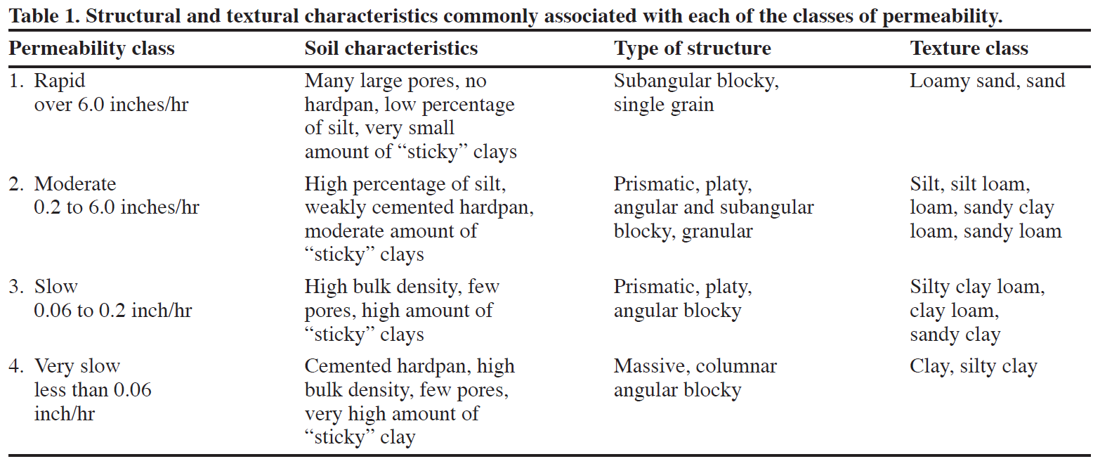
PART 2 – Recommended Conservation Treatment
20 points total; 13 points from vegetative, 7 points for mechanical treatments
A scenario will be described for the site as farmed annually, pasture with introduced plants, or native rangeland, forest, or riparian. Using the information from Part 1 (Soil Characterization) students will then identify the most appropriate treatments or practices that should be applied to address concerns and improve value of the site for desired use. Vegetation or mechanical treatments that would be viable to use for the given area and designated use for the land. Land management treatments or practices are outlined below based in part on effectiveness given Land Capability Class.
| Slope___________________ | Possible Land Class |
| Nearly Level (0-1%) | I |
| Gently Sloping (1-3%) | I |
| Moderately Sloping (3-5%) | III |
| Strongly Sloping (5-8%) | IV |
| Steep (8-15%) | VI |
| Very Steep (>15%) | VII |
| Depth of Soil to restricting layer | Possible Land Class |
| Very Shallow (<10 inches) | VII |
| Shallow (10 to 20 inches) | IV |
| Deep (>20 inches) | I |
| Texture of Topsoil | Possible Land Class |
| Course-textured (Sand & Loamy Sand) | III |
| Moderately Course-textured (Sandy Loam) | II |
| Medium-textures (Loam & Silt Loam) | I |
| Moderately fine-textured (Clay Loam, Sandy Clay Loam & Silty Clay Loam) | I |
| Fine-textured (Sandy Clay, Clay and Silty Clay) | III |
| Permeability____________ | Possible Land Class |
| Rapid | III |
| Moderate | I |
| Slow | I |
| Very Slow | III |
Recommended Conservation Treatments:
The practices listed below include vegetative and mechanical treatments that can be applied to improve soil conservation and land productivity. Whether or not a specific treatment will be effective depends on Land Capability Class and the desired land use outlined in the scenario. The 20 practices listed below are the same as those listed in the National FFA CDE guidelines.
Each participant should mark all practices that are appropriate for the land’s capability and potential to meet desired land use. One point will be deducted for each recommended or desirable practice that is not marked. A point will also be deducted if a practice is marked that would not be recommended or desirable given the described scenario.
Vegetative Treatments (Applicable to Land Capability Classes I through VIII)
- Row crop/occasional soil conserving crop – Class I lands are capable of nearly continuous cropping and are suited for row crops. However, even Class I lands require practices to reduce risk of soil erosion once every five to seven years. These practices may include using close-seeded crops where the rows are close together or inclusion of legumes in the rotation.
- Row crop/frequent soil conserving crop – Class II land require inclusion of soil conserving practices such as legumes or hay in the rotation every fourth or fifth year.
- Row crops not more than 2 out of 4 years – Class III lands have characteristics that limit their potential to produce row crops on a regular basis. These lands require inclusion of close-seeded crops or crops such as legumes or hay in the rotation two out of every four years.
- Row crops not more than 1 out of 5 years – Class IV lands require careful management and are seldom able to produce row crops. These lands require inclusion of hay or close-seeded crops in the rotation four out of every five years with row crops being planted only once every five years.
- Return crop residue to the soil – Some Class I through IV lands may benefit from practices to maintain and return crop residue to the soil each year including not burning crop residue and tilling residue into the soil at the end of the cropping season.
- Practice conservation tillage – Land in classes I through IV may require conservation tillage practices such as no-till farming, cover crops, contour farming and grassed waterways.
- Establish recommended grass or grasses and legumes – Lands in classes IV, V, VI and VII that are highly susceptible to erosion or are not capable of sustained crop production can be planted to perennial grasses or grass and legume mixes to produce hay or be grazed by livestock.
- Proper pasture and range management – Lands maintained as pastures and composed of perennial grasses, legumes, or shrubs often include lands in classes IV, V, VI, and VII. These lands require proper management for hay production or grazing. Management practices may include fertilization, targeted grazing, or application of weed control practices.
- Protect from burning – Lands highly susceptible to wind erosion, annual grass invasion, or those being maintained as desirable shrublands should be protected from prescribed fire and wildfire.
- Control grazing – Livestock grazing should be carefully managed on lands with perennial forage plants that are maintained for livestock grazing. Proper grazing management would include rotational grazing with occasional rest or deferment from grazing.
- Plant recommended trees – Planting trees is recommended on lands susceptible to wind erosion by planting windbreaks or establishing woodlands. Trees may also be recommended on Class VII and VIII where a forested ecosystem could be maintained.
- Harvest trees selectively – Forested land (usually Class VIII) with mature trees suitable timber production can be selectively harvested.
- Use only for wildlife or recreation area – Class VI, VII and VIII lands that cannot be sustainably grazed livestock or used for timber harvest can be managed for recreation, wildlife, wetland, or riparian conservation.
Mechanical Treatments (Applicable to Land Capability Classes I through VIII)
- Control brush or trees – Undesirable shrubs can be controlled by specialized machinery, hand cutting, prescribed fire, or chemical spray to improve land for livestock grazing, wildlife habitat, or preparation for hay production or farming. Woody plant control may be valuable on land of Class I through VIII depending on desired land use.
- Terrace and farm on contour – Excessive movement of water and soil down slopes can be reduced by farming on a contour or at right angles to the slope. This practice should only be applied on fields larger than 2 acres having a slope of 3% or greater.
- Maintain terraces – When terraces are constructed to slow water erosion they will need occasional maintenance to re-establish furrows or banks to slow soil and water movement downslope.
- Construction diversion terraces – Extensive water runoff on sloping lands may require the development of channels to divert water from slopes into a pond or holding area to hold water so it can slowly seep into the land.
- Install drainage system – Some farmed areas occur where underground drainage is inadequate and drainage systems can be installed to reduce water logging and improve crop production.
- Control gullies – Gullies can form in areas where water concentrates in drainages between hills. The severity of gullies depends on the slope, soil texture, subsoil structure, and presence of restricting layers. Several conservation practices can be applied to reduce the presence or severity of gullies.
- No mechanical treatment needed – This box must be marked when no mechanical practices are necessary to conserve the soil or improve productivity of the land.